Position Statement: Elevated buildings in areas of flood risk
What is an elevated building?
A building where structures such as pillars or stilts are used to raise it above the expected flood water level. The ground below the building remains at risk of flooding and allows for the free flow of water.
Context for this position statement
This position statement constitutes part of ‘relevant SEPA advice’ as referred to in criterion a) iv of the National Planning Framework 4 (under Policy 22: Flood Risk and water management). It applies only where such structures are used to enable development that would not otherwise be acceptable according to Policy 22.
It is important to highlight that this position statement addresses all matters that are within SEPA’s flood risk remit only. Local authorities must ensure elevated buildings are structurally safe and capable of being maintained for their lifetime. SEPA not opposing elevated buildings in the clearly defined circumstances below does not mean such development is achievable. Decision makers must also determine development proposals in the context of other applicable policy and regulatory frameworks, and these are not covered in this position statement.
In accordance with Policy 22, sites suitable for the development of elevated buildings must be identified through the development planning process, where the need to manage flood risk rather than avoid it can be considered alongside and balanced with other policy and placemaking considerations. Avoiding development in a flood risk area is still the best approach to managing flood risk, both now and in the future – in most cases this means avoiding development completely. However, in managing climate change there may be a need to bring previously used urban land near our rivers and coasts back into positive use and to enable existing built-up areas to adapt to increasing flood risk. This must happen in a way that ensures there is no unacceptable risk from flooding to people and places, and that those places are safe and resilient in the long term.
Also, in accordance with Policy 22, sites must be previously used, and in a built-up area.
SEPA will apply this position statement where the provisions of Policy 22, as described above, have been met.
Position statement
All underlined terms are defined in the glossary.
SEPA will not oppose elevated buildings on flood-risk grounds where we are certain that all of the following exceptional circumstances are met:
- The underside of the building must be above the height of the design flood level, plus an allowance for freeboard.
- The proposed development must have a neutral or better impact on floodplain capacity.
- Proposals must not create an island of development (i.e. development must adjoin developed areas outwith the flood risk area); and
- Safe, flood free pedestrian access and egress from the building to a place of safety outwith the flood risk area must be provided and secured in perpetuity.
A detailed flood risk assessment will be required to demonstrate how these criteria are met.
Detailed advice
There is a requirement for the first occupied or utilised floor of the building to be above the design flood level, regardless of the proposed use of that floor. Elevated buildings designed to manage flood risk must be safe to use and resilient for the long term, so even where this level is proposed for occupation by a lower vulnerability use, it is capable of being changed later. This will be achieved because there is a requirement for the underside of the building to be above the design flood level.
In the area below the first occupied or utilised level of the building, the building structure must be designed, used, and maintained to allow the free conveyance and/or storage of water up to and including the design flood level throughout the lifetime of the development. This can be achieved by ensuring openings are designed to be as large as technically feasible and not enclosed in any way, to reduce the risk of blockage by mobile debris during a flood, and ensuring this area is unused in perpetuity (including not for storage, refuse or parking uses), which may need to be secured via a planning mechanism (i.e., condition or legal agreement - for the planning authority to advise). The underside of the building should be higher than the design flood level, including an allowance for freeboard, to have a neutral impact on the capacity of the floodplain.
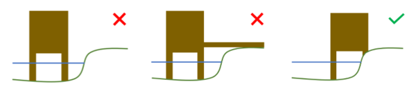
To ensure that elevated buildings do not create islands of development, at least one side of any building of this nature must directly adjoin land which is out with the flood risk area. The purpose of permitting a more adaptive approach to these developments is to create places which are safe and resilient for the long term, which requires a higher level of flood resilience than is required for some other types of development. Using a connecting walkway across land which would flood is not a suitable way to achieve connection to higher ground because it will mean the building is an island; it may also limit the future adaptability of the building. The diagrams below illustrate these points:
Elevated buildings may fail, as with any built structure that becomes subject to fast flowing water and mobile debris. Flood water is powerful, and ensuring structures continue to function through likely repeated inundations requires purposeful consideration and design. SEPA has no remit to advise on structural stability - building standards are set by the Scottish Government and administered by local authorities. It is the responsibility of the developer/building owner to ensure that buildings are structurally safe and compliant with the building warrant as approved by the local authority. Maintenance of the building is the responsibility of the building owner/operator.
A detailed flood risk assessment will be required to support applications for most developments of this type, unless sufficiently detailed flood risk assessment or study information already exists. The assessment must meet the usual requirements set out in Technical Flood Risk Guidance for Stakeholders: SEPA requirements for undertaking a Flood Risk Assessment and is needed to demonstrate:
- The design flood level using the (latest available) information in Climate change allowances for flood risk assessment in land use planning
- The availability of land outwith the flood risk area to which the building will adjoin
- The neutral impact of the development on the capacity (both conveyance and storage) of the flood risk area
- Sensitivity and uncertainty analysis to support the freeboard allowance provided
In this context freeboard is the difference between the design flood level and the underside of the building. It is an important safety margin designed to allow for the uncertainties involved in flood estimation and physical factors that cannot be assessed and vary between sites e.g., post construction settlement and wave action. In many cases an adequate freeboard allowance is 600mm above the design flood level[1] (in some situations, a more detailed assessment of appropriate freeboard will need to be carried out).
The maximum level (height) that the flood water is expected to reach, during the design flood. The design flood is the hypothetical flood that has been used to design the development. For the avoidance of doubt, the design flood is the same scenario as the one used to define the flood risk area, as explained above.
floodplain capacity
The ability the floodplain has to store and convey (allow the free movement of) floodwater. If the volume of water that can be conveyed through, or stored within the floodplain is reduced, this can result in flooding being increased in other areas.
flood risk area (as defined in NPF4)
At risk of flooding or in a flood risk area means land or built form with an annual probability of being flooded of greater than 0.5% which must include an appropriate allowance for future climate change. This risk of flooding is indicated on SEPA’s future flood maps or may need to be assessed in a flood risk assessment. An appropriate allowance for climate change should be taken from the information in Climate change allowances for flood risk assessment in land use planning. The calculated risk of flooding can take account of any existing, formal flood protection schemes in determining the risk to the site. Where the risk of flooding is less than this threshold, areas will not be considered ‘at risk of flooding’ for planning purposes, but this does not mean there is no risk at all, just that the risk is sufficiently low to be acceptable for the purpose of planning. This includes areas where the risk of flooding is reduced below this threshold due to a formal flood protection scheme.
Buildings located above the design flood level but surrounded by lower ground at flood risk on all sides not directly connected to areas outwith the flood risk area. To avoid doubt, the inclusion of a raised walkway does not stop a layout being considered an island of development.
safe, flood free pedestrian access and egress
A route for the movement of people (not vehicles) of all abilities (on foot or with mobility assistance).
The lowest level of the building structure that could impede the flow of water underneath it.
[1] In line with CIRIA Guidance C624 (Development and Flood Risk – Guidance for the Construction Industry 2004)
First published: Version 1 - January 5, 2022
Last updated: Version 2 - September 8, 2023