NGR Help
Find your National Grid Reference (NGR)
|
SEPA have developed a web based NGR tool using online maps to help determine a National Grid Reference. By entering your postcode a map of your area will displayed. By clicking on the map a 10 character National Grid Reference will be displayed for your use. |
 |
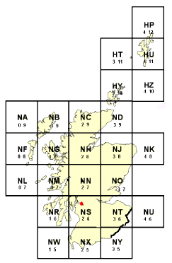
Reading a National Grid Reference (NGR)The British National Grid System divides the United Kingdom into a grid of 100km squares and each square has a pair of identifying letters. This grid appears on all OS Landranger and Pathfinder maps. To read your National Grid Reference (NGR)
|
 |
Example
- In this example, our location is shown on an OS Landranger map.
- The location lies within NS square on the national grid (indicated in the diagram above).
- The Easting (X) map coordinate is 4227.
- The Northing (Y) map coordinate is 8364.
- The NGR for this location is: NS42278364
note